
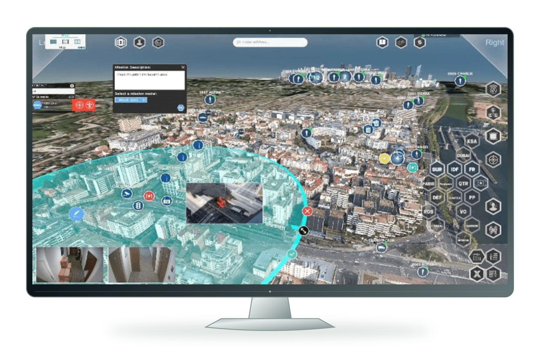
Command & autonomy

HelloGeo Defence

Multi-domain operational intelligence

PRODUCT OVERVIEW

What it brings
to the workflow.

HelloGeo Defence is a secure, mission-ready geospatial and autonomous-operations platform designed for defence, security and critical infrastructure protection.

The platform unifies UAV operations, ground-based sensors, maritime systems, GIS intelligence, AI analytics and command-centre workflows—enabling organizations to maintain situational awareness, coordinate responses and make informed decisions across complex operational environments.

CAPABILITIES / 14 FEATURE GROUPS

Go deeper into
the product.

Explore the published capability areas. Product configuration and deployment scope determine availability.

01 Multi-Domain Mission Planning
  • Plan air, land, maritime and subsurface missions
  • Define waypoints, routes, grids and patrol patterns
  • Establish operational boundaries and exclusion zones
  • Configure mission parameters for each asset type
  • Schedule recurring or on-demand operations
  • Support joint and coalition mission planning
  • Save and reuse mission templates
  • Review estimated mission duration and resource requirements
02 Integrated Command and Control
  • Unified operational picture across all domains
  • Real-time asset tracking and status monitoring
  • Live telemetry, video and sensor-feed access
  • Multi-site supervision from command centres
  • Role-based access for operators, analysts and commanders
  • Secure communication and data sharing
  • Incident and alert management
  • Complete operational audit trails
03 Unmanned Systems Integration
  • Support for UAVs, UUVs, USVs and UGVs
  • Integration with compatible autonomous platforms
  • Automated launch, recovery and docking workflows
  • Autonomous station and drone-station integration
  • Payload configuration and sensor management
  • Fleet and asset readiness monitoring
  • Mission history and utilization tracking
  • Common interface across mixed fleets
04 Geospatial Intelligence
  • Interactive 2D and 3D geospatial visualization
  • Integrated GIS, satellite and terrain basemaps
  • Overlay operational layers, boundaries and assets
  • Import KML, KMZ, GeoJSON and vector data
  • Analyse terrain, line-of-sight and coverage
  • Create custom maps and intelligence products
  • Publish secure map views to stakeholders
  • Maintain geospatial data and mission histories
05 Live Sensor and Payload Monitoring
  • Real-time video streaming (RGB, thermal, IR)
  • Supported sonar, radar and acoustic monitoring
  • Environmental and atmospheric sensor integration
  • Payload control and camera operations
  • Geotagged observation recording
  • Anomaly detection during live missions
  • Secure remote viewing for authorized personnel
  • Incident capture and evidence management
06 AI-Assisted Intelligence
  • Automatic object detection and classification
  • Change detection across survey dates
  • Anomaly identification in imagery and sensor data
  • Thermal and multispectral analysis
  • Activity and pattern recognition
  • Confidence-based alerts and prioritization
  • Automated intelligence-product generation
  • Integration with analyst review workflows
07 Maritime and Littoral Operations
  • Port and harbour surveillance
  • Exclusive economic zone (EEZ) monitoring
  • Shipping lane and vessel tracking
  • Subsurface threat detection
  • Bathymetric and hydrographic intelligence
  • Coastal and shoreline monitoring
  • Underwater infrastructure inspection
  • Search and rescue coordination
08 Perimeter and Border Security
  • Persistent surveillance and monitoring
  • Border and sensitive-zone protection
  • Intrusion detection and threat assessment
  • Automated patrol and response missions
  • Multi-sensor perimeter integration
  • Incident and evidence management
  • Secure communication with response teams
  • Operational record maintenance
09 Intelligence, Surveillance and Reconnaissance
  • Mission-specific ISR planning and execution
  • Real-time intelligence collection and dissemination
  • Multi-intelligence data integration
  • Target identification and tracking
  • Battle-damage assessment
  • Evidence and intelligence reporting
  • Secure data sharing with allied forces
  • Complete operational intelligence records
10 Secure Collaboration and Command
  • Role-based access and need-to-know controls
  • Secure messaging and communication
  • Incident assignment and escalation workflows
  • Shared operational notes and annotations
  • Command-centre dashboard views
  • Controlled stakeholder access
  • Standard operating procedure integration
  • Audit-ready collaboration records
11 Digital Twins and Simulation
  • Create 3D representations of operational environments
  • Integrate terrain, infrastructure and asset data
  • Simulate mission scenarios and responses
  • Visualize operational plans and contingencies
  • Compare current and historical conditions
  • Support training and mission rehearsal
  • Link simulation results with operational planning
  • Maintain simulation and training records
12 Cyber-Secure Deployment
  • End-to-end data encryption
  • Multi-factor authentication
  • Comprehensive audit and activity logs
  • Air-gapped and sovereign deployment options
  • Federal and defence security compliance
  • Zero-trust architecture support
  • Secure API gateways and integrations
  • Continuous security monitoring
13 Data and Knowledge Management
  • Centralized operational data repository
  • Searchable mission and intelligence archives
  • Metadata, tagging and version control
  • Data retention and classification policies
  • Controlled information sharing
  • Export data to standard formats
  • Integration with defence intelligence systems
  • Maintain operational knowledge base
14 Enterprise Integration
  • Integration with existing command and control systems
  • API-first architecture for interoperability
  • Connection with GIS, ERP and logistics systems
  • Sensor and IoT network integration
  • Automated data and intelligence workflows
  • Webhook and alert integrations
  • Custom connectors for defence systems
  • Support for coalition interoperability standards
PROJECT CONTEXT

From capability
to useful work.

Operational Workflow
  1. Plan

    Define the mission objective, area, assets and operating parameters

  2. Prepare

    Configure assets, sensors and operational systems

  3. Execute

    Launch missions and monitor live operations

  4. Monitor

    View telemetry, video, sensor data and alerts

  5. Analyse

    Process captured data and generate intelligence

  6. Act

    Share findings, assign actions and maintain records

Deployment Configurations
Fixed Command Centre
Permanent installation for operational headquarters and command centres.
Mobile Command Post
Vehicle-mounted or deployable systems for forward operations.
Remote Forward Base
Deployed at forward operating locations for perimeter and area surveillance.
Distributed Sensor Network
Multiple fixed and mobile assets connected through centralized command.
Sovereign Secure Cloud
Nation-state or defence-organization private cloud deployment.
Air-Gapped Environment
Fully isolated deployment for highly sensitive and classified operations.
Applications
  • Persistent surveillance and monitoring
  • Intrusion detection and response coordination
  • Border patrol and reconnaissance
  • Illegal activity identification and evidence management
  • Multi-sensor integration and analysis
  • Coordination with border protection agencies
  • Port and harbour surveillance
  • EEZ and shipping lane monitoring
  • Subsurface threat detection
  • Vessel tracking and identification
  • Coastal and littoral operations
  • Search and rescue coordination
  • Perimeter monitoring and security
  • Power plant and facility surveillance
  • Pipeline and utility corridor inspections
  • Data centre and communications security
  • Threat assessment and incident response
  • Maintenance and security reporting
  • Long-range surveillance missions
  • Intelligence collection and analysis
  • Target identification and assessment
  • Counterintelligence and monitoring
  • Battle-damage assessment
  • Secure intelligence dissemination
  • Rapid situational assessment
  • Search and rescue coordination
  • Damage mapping and assessment
  • Resource and asset management
  • Evacuation and route planning
  • Incident documentation and reporting
  • Transportation and logistics monitoring
  • Railway, highway and bridge inspections
  • Port and harbour operations
  • Airport and aviation security
  • Communication infrastructure protection
  • Resilience and continuity planning
  • Event and crowd monitoring
  • Critical building surveillance
  • Urban reconnaissance and mapping
  • Public safety coordination
  • Emergency response support
  • Integration with city command centres
  • Pollution and disaster monitoring
  • Climate vulnerability assessment
  • Environmental impact documentation
  • Marine and coastal protection
  • Natural resource monitoring
  • Sustainability and compliance reporting

Product content aligned to the HelloGeo official catalogue, reviewed 2026-10-09. Original product catalogue

PRODUCT RESOURCES

Explore it with your team.

THE NEXT STEP STARTS WITH A CONVERSATION

Bring us the challenge.
Let’s build the connection.

Your team knows the site. We know the spatial workflow. Together, we can define a practical way forward.